Deep within the forests lies a wonder of both ancient and natural Belize. Following a 45-minute drive from San Ignacio and a 45-minute hike through the beautiful Tapir Mountain Nature Reserve with numerous jungle stream crossings, visitors find a crystal-clear stream flowing from the cave opening.
Take a short swim into the cave and a guided hike through the passage to one of the most impressive Maya sites in Belize. Also known locally as “Xibalba,” you’ll find evidence of ceramics, stoneware and skeletons. One artifact named the “Monkey Pot” is one of just four found in Central America. One skeleton, known as “The Crystal Maiden,” is the calcified bones of a teenage girl, giving the skeleton a sparkling appearance.
Please be aware that seeing the amazing ATM is a bit physically demanding and you’ll be swimming through the cave at points. If you’re not currently in shape, this could be your incentive to get fit.
Believe us, it’s worth it.

Altun Ha, the archaeological site closest to Belize City, was a major Maya culture ceremonial center and the discovery site of Belize’s famous Jade Head.
Altun Ha functioned as a central trading link between the Caribbean coast and Maya centers in the interior during the Maya Classic Period. Two (2) main plazas with roughly 13 Maya temples and residential structures have been excavated here.
A unique feature of this site is the absence of carved stelae, while its most notable artifact is a large jade carving of the Maya sun god “Kinich Ahau.” Weighing almost 10 pounds, this 6-inch carving is the largest carved jade object to be found in any Maya community in the region. A replica of the “Jade Head,” a national treasure, is on display at the Central Bank of Belize, and its likeness is watermarked on all Belizean currency.
Did you know…
The Altun Ha Jade head stands 14.9 cm (6 inches) high and weighs 4.42 kg (9.75 Lbs). The jade from which this artifact was made was imported from ancient mines along the Motagua River valley in eastern Guatemala. Today the jade head is considered the crown jewel of Belize.


Just a short walk from the present-day town of Cahal Pech, also known as “The Place of Ticks” in Yucatecan Maya, this Maya site is very convenient to visit. Located in San Ignacio along the banks of the Macal River in the Cayo District, Cahal Pech was a ceremonial center, with temples, palaces and a ball court. The site offers you a spectacular panoramic view of San Ignacio and the Belize River Valley.
The site is particularly important for the information it has provided on the earliest Maya settlements in the region, for its large number of Pre-classic figurines and for its complex residential architecture. Indeed, its maze of interconnected rooms provide an excellent example of Late Classic Maya palace architecture.
Cahal Pech is located on an imposing hill that overlooks the twin town of San Ignacio and Santa Elena. First settled between 1200-1000 B.C., the site is one of the oldest settlements in the lowland Maya world. By Late Pre-classic times (300 B.C.-250 A.D.), Cahal Pech had developed into one of the most imposing centers in the Belize River Valley. Its Pre-classic inhabitants acquired exotic goods from the Caribbean coast and highland Guatemala and shared the symbol systems of communities across Mesoamerica. The central precinct of the site consists of 36 structures, which include tall temple pyramids, two (2) ballcourts and several range-type buildings or palaces. The tallest temple in the central core is Structure A1, which stands at 77 feet high.

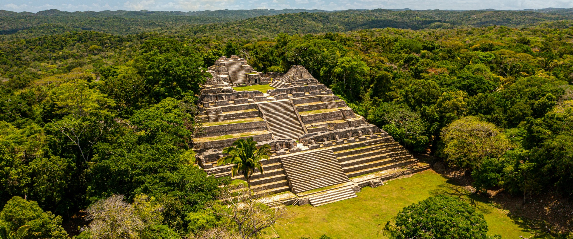
One of Belize’s best ancient Maya temples, Caracol is deep in the heart of the Chiquibul Forest Reserve of the Maya Mountains in the Cayo District.
Covering an area of nearly 25,000 acres, this site is impressive not only for its size, but also for its immense agricultural field system and elaborate city planning. Caracol is one of the most pristine and well-kept Maya sites in Belize. If you want to see an amazing piece of our history, head to Caracol.
Numerous carved monuments establish that Caracol was a major player in the geopolitics of the Classic period Maya world. It was an ally of Calakmul in Campeche, Mexico and engaged in several wars with neighboring polities, such as Tikal, Naranjo and Ucanal in Guatemala.
Did-You-Know?
The main temple, Canaã (“sky place”), offers you incredible views of the surrounding jungle. At 143 feet high, it is the tallest manmade structure in the country. The ancient Maya created not only a spectacular structure, but also incorporated excellent acoustics so that priests and rulers using normal speaking voices could be heard clearly by the masses assembled in the plaza below.

Take a short boat ride across the Corozal Bay to Cerros or an adventurous trip by road. As the only Maya site in Belize situated on the coast, Cerros is located on a northern peninsula in the Bay of Chetumal, across from Corozal Town.
Cerro Maya was the first Maya trading center built along the seaside in 50 B.C. Maya traders arrived by canoe from the coast through the Bay of Chetumal, as well as from upriver on the Rio Hondo in the north and the New River to the south.
Three (3) large buildings dominate several plazas flanked by pyramids. While two (2) of these structures are facades adorned with stucco masks, the masks has since been covered to protect them from erosion. With the tallest structure rising 72 feet above the plaza, the panoramic view atop offers the Bay of Chetumal, Corozal Town and the mouth of the New River, which leads to the Lamanai temples.
The Maya living here also built an extensive canal system and utilized raised-field agriculture. It’s truly a sight to see.
The most famous building at Cerros is a temple designed as Str. 5C2nd. The structure is decorated with two (2) pairs of large painted stucco masks that flank the central stairway. The lower eastern mask represented the rising sun. Its western counterpart was the setting sun. The upper eastern mask was Venus as the morning star and, to the west, Venus as the evening star. One theory holds that when the site’s ruler conducted rituals on the temple, he was symbolically placed at the center of the cosmos as a demonstration of his power and right to rule. The Preclassic dates of the masks on Str. 5C2nd are great examples of the early achievements of ancient Maya astronomy and the complexity of their religion and cosmology.
Did-You-Know?
Ancient canals used for water management and flood control encircle the site core. Global warming, in the form of rising sea levels, has been affecting the site. Several mounds are now under water along the northern coastline.

The isolated El Pilar Ancient Maya Temple is three times larger than Xunantunich and is still being excavated today. The focus here is showing how regular Maya lived by uncovering common homes and planting gardens and crops used by the Maya. El Pilar was occupied from 800 BC to 1000 AD and, at one time, had over 20,000 residents. For a look at how the regular Maya lived, El Pilar is the place to go.
El Pilar is one of Belize’s largest Classic period Maya sites. The center has a well-defined civic/ceremonial section that includes both private and public areas. With 15 courtyards or plazas, the complexity of El Pilar’s epicenter suggests the site was of considerable regional importance during the Late Classic period. Beyond the central precinct, settlement density is also very high, suggesting a large population lived in the site’s sustaining area. Within the site center there are several large temples, palaces and elite architecture. The tallest structure stands around 60 feet above the plaza. Other architectural features include at least one ball court and several reservoirs that served as water catchments. Although there has been limited archaeological work at El Pilar, substantial efforts have been expended to develop the site’s natural forest environment. East of the site’s core, in a section known as the Garden Area, a small residential plaza was conserved in an effort to demonstrate the nature of Maya households and their connection to the flora, fauna and natural ecology.
Did-You-Know?
El Pilar is one of the largest Maya sites in the Belize Valley and lies approximately 50 kilometers from the major prehistoric city of Tikal in Guatemala.


Boat up the New River from Orange Walk to the Lamanai Maya temples. On your boat ride, in addition to some amazing scenery, you’ll see wildlife like snail kites, jacana, morelet’s crocodile and iguanas.
Lamanai was occupied for more than 3,000 years, up until European contact. The Archaeological Reserve not only contains a museum with ancient Maya artifacts, but visitors can also see the remnants of two (2) 16th century Spanish churches and a colonial sugar mill established in 1860.
A major attraction of Lamanai is the well-preserved mask of a Maya ruler emerging from a crocodile headdress.
Lamanai, one of Belize’s largest Maya sites, sits on the bank of the 30-mile-long New River Lagoon in the Orange Walk District. It features monumental architecture of temples and palaces dating from the Classic and Pre-Classic Periods. Set in tropical forest and providing amazing views from several of its large temples, Lamanai provides you a unique glimpse into the culture of the Maya and the biological diversity of the tropical rainforest.
Lamanai is the community with the longest history of human habitation in Belize. It was settled around 900 B.C and was still occupied two and a half thousand years later, when Spanish missionaries arrived to the site in 1544. During their almost century- long domination, the Spanish built two “Ramada” Churches that were used in their efforts to Christianize the site’s inhabitants. Eventually, in 1640 the Maya in several frontier towns rebelled against churches and villages throughout Belize. By the 1800’s, investors began a sugar operation at Lamanai. A dramatic fall in world sugar prices, and outbreaks of malaria among the workers resulted in failure of the enterprise, and the mill and farm were abandoned, just a few years after its establishment.
Did-You-Know?
Liquid mercury was discovered in an offering that was placed below the ballcourt marker at this site! This represents one (1) of only two (2) examples of mercury found in the Maya world (the other was at Caracol, also in Belize).

The Maya temples of Lubaantun are unique in that they were built entirely without the aid of mortar. Each stone was carefully measured and cut to fit the adjoining one.
Situated above a tributary to the Columbia River, Lubaantun, sits near the Maya village of San Pedro Columbia in the Toledo District, 13 miles from Punta Gorda Town. Consisting of 14 major structures grouped around five main plazas, Lubaantun was built in the Late Classic period and is the largest ceremonial center in southern Belize.
The ancient city of Lubaantun flourished for over 150 years, from about 700 to 850 A.D. Archaeologists believe that, like other sites in southern Belize, Lubaantun was occupied by the Manche Chol Maya, who moved into the area from the southwest, possibly from the site of Pusilha (Belize) or other neighboring cities in Guatemala. Having constructed their community on the foothills overlooking the banks of the Columbia River, the new settlers rapidly established their regional capital at Lubaantun. Their location, adjacent to fertile soils, allowed them to grow important cash crops, such as cacao, which they exported to their neighbors in exchange for obsidian, jade and other exotic goods. The site core extends for nearly a kilometer along a north-south ridge and contains large civic architecture that served ritual and administrative purposes. The western and northern sections of the center has a series of terraced platforms with residential buildings that were likely used as dwellings for the elites. The site has two (2) ball courts, one at the southern end of the acropolis and the second to the northeast of the main plaza.
Did-You-Know?
There are no stelae at Lubaantun, which is intriguing, since other sites in the area have stelae carved with dates and hieroglyphic inscriptions. The only carved monuments at the site are ball court markers, which were found in the epicenter. Hundreds of Terminal Classic figurines and whistles have been discovered at Lubaantun.

Nim Li Punit, located near the village of Indian Creek in the Toledo District, is well known for the number of stelae discovered. Nim Li Punit gets its name from a carving on the longest of the site’s 26 stelae. The longest stelae is carved with a figure wearing a large headdress and, at a length of 30 feet, is the longest discovered in Belize and one of the tallest in the Maya world.
Nim Li Punit is situated in the foothills of the southern Maya Mountains. To the east of the ridge lie the flat coastal plains that extend to the Caribbean Sea. The site center consists of three major groups with monumental architecture. The southern group contains the stelae plaza, the ball court, a 12-meter high structure and several palaces. Excavations have uncovered a large tomb, which contained the remains of five individuals, 40 ceramic vessels and various other artifacts. In the Stelae plaza, there were more than 16 monuments. Seven of these were inscribed with calendar round dates that fall within the late Classic Period. Most of the carved stelae depict elite rulers, who appear to be scattering copal onto flaming braziers. The east group is comprised of several modified terraces, on which a large number of structures are erected, while the west group has about 14 mounds that were constructed atop two large terraces.
Did-You-know?
The 17-meter long Stelae 14 represents the longest stelae yet discovered in Belize (and possibly the second longest in the Maya area).

Grab an inner tube and take a float through the Caves Branch River. The Nohoch Che’en Caves Branch Archaeological Reserve is home to caves the ancient Maya held sacred. Tours run daily, so stop by—or should we say, float by.

The Marco Gonzalez Maya Site is located in Ambergris Caye. It was once a Maya trading post with 20,000 inhabitants, and many Maya fishing artifacts can be found here. The site is now open to the public for exploration, so if you would like a little time away from the beach, check it out.

Located about one mile from the town square, this great historical Maya site commemorates the birth place of the Mestizos. Once atop the main temple, visitors can enjoy a panoramic view of the town.
If you’re looking for a short trip to ancient Maya sites while staying in Corozal, Santa Rita is just outside of town and gives you a chance to see some without traveling to a remote area. Santa Rita was founded in 1500 BC and was one of the district’s major trading centers. There are few structures uncovered and no guides to show you around. But with a little imagination, you should be able to transport yourself back in time or, at least, get some nice pictures.

Serpon Sugar Mill is the country’s first historical reserve. Hidden in the jungle one mile in on the access road to the village of Sittee River is an important landmark in Belize’s colonial history. It is the remnants of the steam powered Serpon Sugar Mill, which was established in 1865 and marked the start of Belize’s industrial era. The mill was bought by William Bowman and it, along with the Regalia, bought and owned by an American, fueled Belize’s economy for about thirty years.
Estimates are that at its peak, the Serpon Sugar Mill was producing and shipping 1,700 pounds of sugar a month. In the late 19th century, Serpon was a technological marvel with its main crusher, boiler, beam engine, furnace, and hot air exchanger – all powered by steam. That was a breakthrough when compared to the manual process used previously by the Mestizos and Mayas.

Take the hand-cranked ferry over the river to Xunantunich, which sits atop a hill overlooking the Mopan River and the Cayo District. The area was a major ceremonial site built on a natural limestone ridge during the Classic Period. It is composed of six (6) major plazas, with more than 25 Maya temples and palaces.
“El Castillo” (the Castle), the largest pyramid at 130 feet above the plaza, has carved friezes on the east and west sides. The frieze on the east has been preserved and covered with a fiberglass replica of the central mask that represents the sun god. It’s flanked by the moon and Venus.
On a clear day, you can see across into nearby Guatemala and near Caracol in the Pine Ridge Mountain Reserve. It’s quite a sight to behold.

Tours
Experience The Adventure
Don’t just see the wonder of Belize, Experience it! From zip-lining through the jungle to standing in ancient mayan ruins to relaxing on the beach, there is something for everyone in Belize.